|
Home
Catalogue
Information
Copyright
Other Stock Image websites

Latest additions -
Athens, ancient ruins, c1775
Pulo Penang, Malaysia, c1840
The Capitol, Washington, 1840
Middlesex county map, 1786
Philadelphia plan (SDUK), 1844
Lancashire county map, 1807
Ireland map, 1773
Austria-Hungary map, 1887
Notre Dame, Paris, 1840
Essex map, 1809
Eastern USA map, 1852
Calcutta view, 1850
Bohemia map, 1773
Dardanelles view, Turkey, 1828
Baltic Sea Tallis map, 1860
Plan of medieval Paris, 1884
Istanbul view, 1770
|
Download Royalty-free Stock Images of antique historical maps of classical to medieval periods
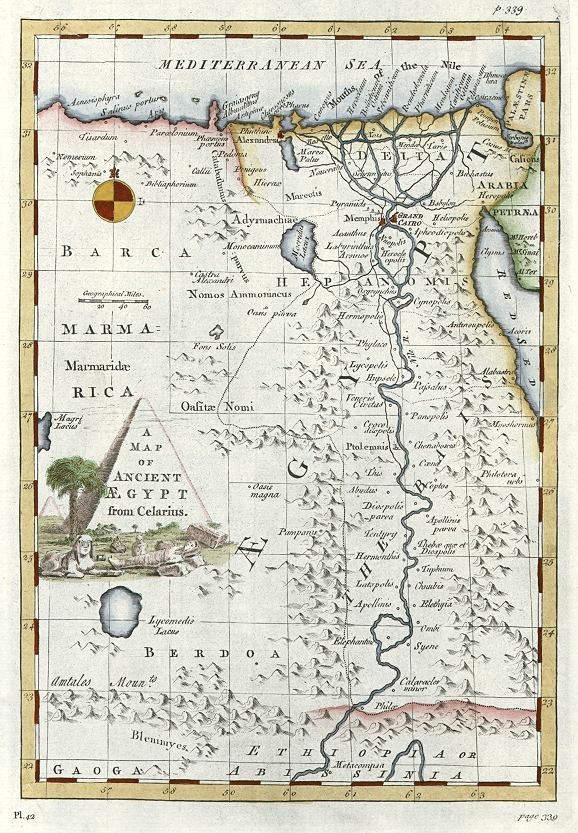
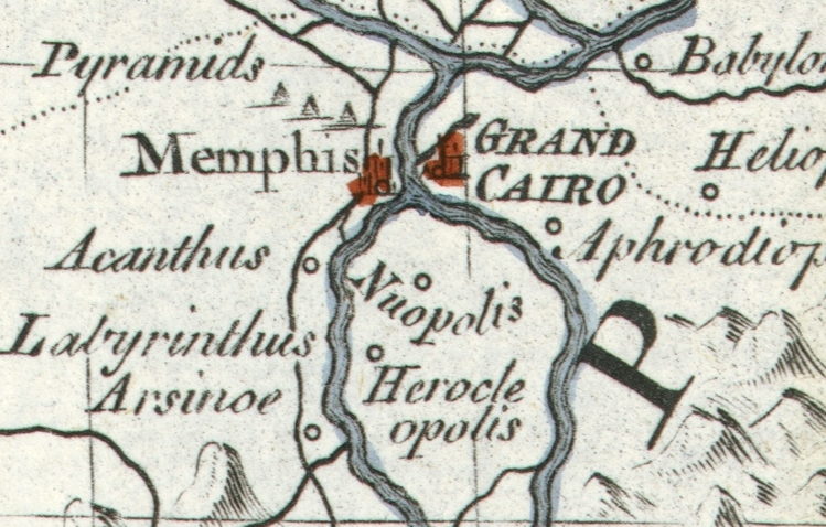
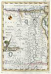 "A Map of Ancient Aegypt from Celarius" engraved by John Hinton(?), published in Stackhouse's History of the Bible, 1744. Copper engraved map with recent hand colour. Click
here for detail showing part
of the map at full resolution (300 dpi). Click the small image
to the left for a larger low resolution version. (Ref sm0205). Digital
image size 13.1 mb at 300 dpi. "A Map of Ancient Aegypt from Celarius" engraved by John Hinton(?), published in Stackhouse's History of the Bible, 1744. Copper engraved map with recent hand colour. Click
here for detail showing part
of the map at full resolution (300 dpi). Click the small image
to the left for a larger low resolution version. (Ref sm0205). Digital
image size 13.1 mb at 300 dpi.
Price 5
USD, Click here to buy
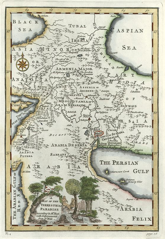
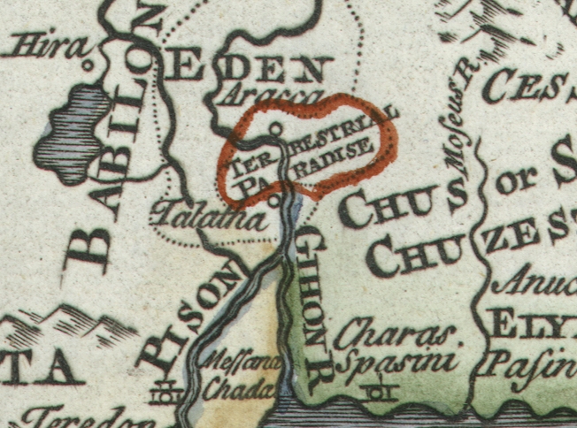
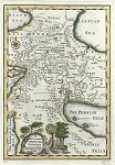 "A Map of the Terrestrial Paradise according to Mr.Huet, with Improvements from Dr.Wells" anonymous engraver, published in Stackhouse's History of the Bible, 1744. The original is a copper engraved map, with recent hand colour. Mainly covers all or part of what is now Georgia, Armenia, Azerbaijan, Turkey, Iran, Iraq, Holy Land and Saudi Arabia. Original size 21 x 30 cms plus margins. Click
here for detail showing part
of the map at full resolution (400 dpi). Click the small image
to the left for a larger low resolution version. (Ref sm0244). Digital
image size 13.2 mb at 400 dpi. "A Map of the Terrestrial Paradise according to Mr.Huet, with Improvements from Dr.Wells" anonymous engraver, published in Stackhouse's History of the Bible, 1744. The original is a copper engraved map, with recent hand colour. Mainly covers all or part of what is now Georgia, Armenia, Azerbaijan, Turkey, Iran, Iraq, Holy Land and Saudi Arabia. Original size 21 x 30 cms plus margins. Click
here for detail showing part
of the map at full resolution (400 dpi). Click the small image
to the left for a larger low resolution version. (Ref sm0244). Digital
image size 13.2 mb at 400 dpi.
Price 5
USD, Click here to buy
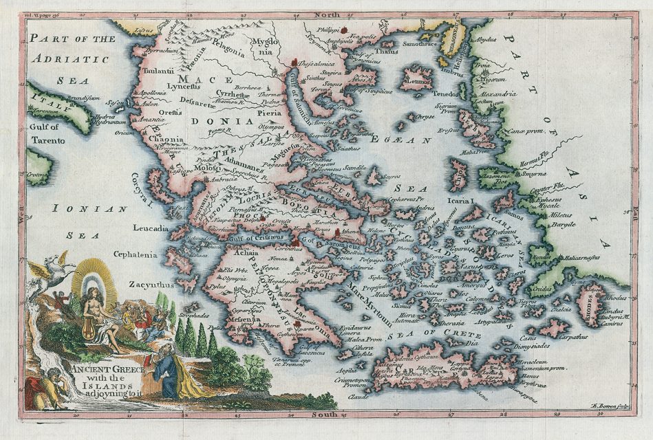
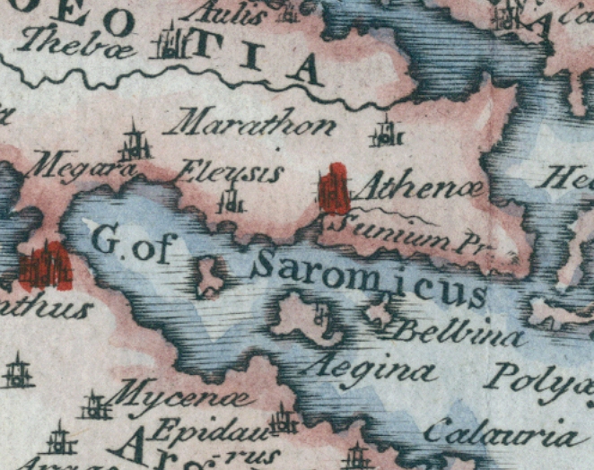
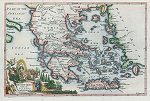 "Ancient Greece with the Islands adjoyning to it" engraved by E.Bowen, published in the Universal History ..., about 1745. The original is a copper engraved map, with recent hand colour. Original size 30 x 20 cms plus margins. Click
here for detail showing part
of the map at full resolution (400 dpi). Click the small image
to the left for a larger low resolution version. (Ref sm0264). Digital
image size 13.6 mb at 400 dpi. "Ancient Greece with the Islands adjoyning to it" engraved by E.Bowen, published in the Universal History ..., about 1745. The original is a copper engraved map, with recent hand colour. Original size 30 x 20 cms plus margins. Click
here for detail showing part
of the map at full resolution (400 dpi). Click the small image
to the left for a larger low resolution version. (Ref sm0264). Digital
image size 13.6 mb at 400 dpi.
Price 5
USD, Click here to buy
_tn.jpg) "Imperium Romanum tempore Constantini Magni" (Roman Empire at the time of Constantine the Great, about 330 A.D.) engraved by E.Luther, published in Stielers Neuster Zeitungs Atlas, 1852. Steel engraved map with original hand colour. Click
here for detail showing part
of the map at full resolution (500 dpi). Click the small image
to the left for a larger low resolution version. (Ref sm0045). Digital
image size 14.5 mb at 500 dpi. "Imperium Romanum tempore Constantini Magni" (Roman Empire at the time of Constantine the Great, about 330 A.D.) engraved by E.Luther, published in Stielers Neuster Zeitungs Atlas, 1852. Steel engraved map with original hand colour. Click
here for detail showing part
of the map at full resolution (500 dpi). Click the small image
to the left for a larger low resolution version. (Ref sm0045). Digital
image size 14.5 mb at 500 dpi.
Price 5
USD, Click here to buy
_tn.jpg) "Empire de Charlemagne en 814 Avec La Division en Trois Royaumes faite en 806 et le partage de Verdun 843 " (Charlemagne's Empire) engraved by Erhard after Vuillemin, published in Atlas Universel D'Histoire et de Geographie, Paris, 1877. Lithographic map with original hand colour. The original has a centre-fold. Click
here for detail showing part
of the map at full resolution (400 dpi). Click the small image
to the left for a larger low resolution version. (Ref sm0045). Digital
image size 13 mb at 400 dpi. "Empire de Charlemagne en 814 Avec La Division en Trois Royaumes faite en 806 et le partage de Verdun 843 " (Charlemagne's Empire) engraved by Erhard after Vuillemin, published in Atlas Universel D'Histoire et de Geographie, Paris, 1877. Lithographic map with original hand colour. The original has a centre-fold. Click
here for detail showing part
of the map at full resolution (400 dpi). Click the small image
to the left for a larger low resolution version. (Ref sm0045). Digital
image size 13 mb at 400 dpi.
Price 5
USD, Click here to buy
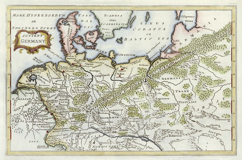
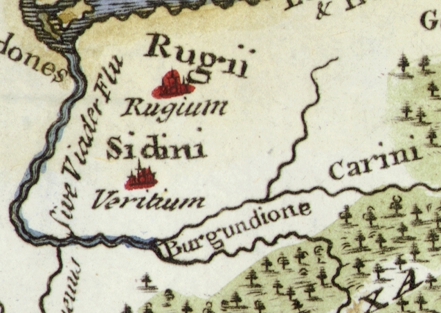
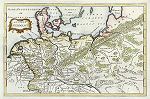 "Antient Germany" (ancient Germany) engraved
by S.Wheatley, published about 1750. The original is a copper engraved map, showing an area between the Rhine River, Alps, Baltic Sea and today's Ukraine. Click
here for detail showing part
of the map at full resolution (400 dpi). Click the small image
to the left for a larger low resolution version. (Ref sm0015). Digital
image size 13.3 mb at 400 dpi. "Antient Germany" (ancient Germany) engraved
by S.Wheatley, published about 1750. The original is a copper engraved map, showing an area between the Rhine River, Alps, Baltic Sea and today's Ukraine. Click
here for detail showing part
of the map at full resolution (400 dpi). Click the small image
to the left for a larger low resolution version. (Ref sm0015). Digital
image size 13.3 mb at 400 dpi.
Price 5
USD, Click here to buy
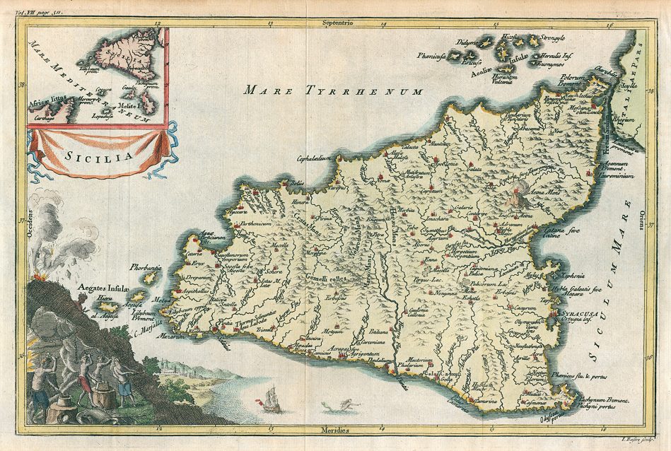
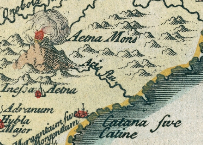
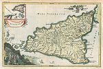 "Sicilia" (ancient Sicily) engraved
by J.Basire, published in the Universal History ..., about 1745. The original is a copper engraved map, with recent hand colouring. Click
here for detail showing part
of the map at full resolution (400 dpi). Click the small image
to the left for a larger low resolution version. (Ref sm0266). Digital
image size 13.5 mb at 400 dpi. "Sicilia" (ancient Sicily) engraved
by J.Basire, published in the Universal History ..., about 1745. The original is a copper engraved map, with recent hand colouring. Click
here for detail showing part
of the map at full resolution (400 dpi). Click the small image
to the left for a larger low resolution version. (Ref sm0266). Digital
image size 13.5 mb at 400 dpi.
Price 5
USD, Click here to buy
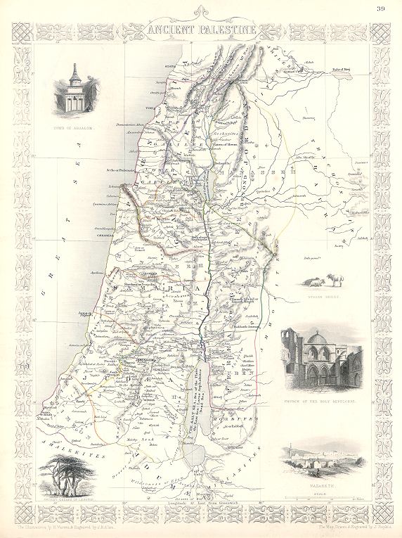
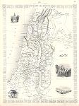 "Ancient Palestine" drawn and engraved by J.Rapkin, published by The London Printing and Publishing Company, about 1853. The original is a decorative steel engraved map with original
hand colouring. Click
here for detail showing part
of the map at full resolution (400 dpi). Click the small image to the left for a larger low resolution version. (Ref sm0201). Digital image
15.3mb at 400dpi. "Ancient Palestine" drawn and engraved by J.Rapkin, published by The London Printing and Publishing Company, about 1853. The original is a decorative steel engraved map with original
hand colouring. Click
here for detail showing part
of the map at full resolution (400 dpi). Click the small image to the left for a larger low resolution version. (Ref sm0201). Digital image
15.3mb at 400dpi.
Price 5 USD, Click here to buy
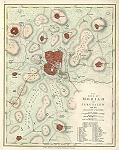
_tn.jpg) "The Antient City of Jerusalem and Places adjacent" engraved
by G.Rollos, published about 1757. The original is a copper engraved plan
measuring 25 x 18.5 cms. Click
here for detail showing part
of the map at full resolution (500 dpi). Click the small image
to the left for a larger low resolution version. (Ref sm0015). Digital
image size 15 mb at 500 dpi. "The Antient City of Jerusalem and Places adjacent" engraved
by G.Rollos, published about 1757. The original is a copper engraved plan
measuring 25 x 18.5 cms. Click
here for detail showing part
of the map at full resolution (500 dpi). Click the small image
to the left for a larger low resolution version. (Ref sm0015). Digital
image size 15 mb at 500 dpi.
Price 5
USD, Click here to buy
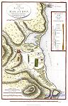
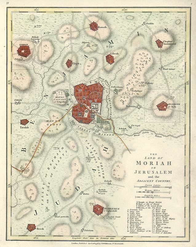
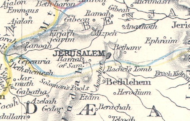
 "The Land of Moriah or Jerusalem and the Adjacent Country" published in Wilkinson's Atlas Classica..., 1807. The original is a copper engraved plan
with original hand colour, measuring 22 x 28.5 cms. Click
here for detail showing part
of the map at full resolution (300 dpi). Click the small image
to the left for a larger low resolution version. (Ref sm0206). Digital
image size 10 mb at 300 dpi. "The Land of Moriah or Jerusalem and the Adjacent Country" published in Wilkinson's Atlas Classica..., 1807. The original is a copper engraved plan
with original hand colour, measuring 22 x 28.5 cms. Click
here for detail showing part
of the map at full resolution (300 dpi). Click the small image
to the left for a larger low resolution version. (Ref sm0206). Digital
image size 10 mb at 300 dpi.
Price 5
USD, Click here to buy
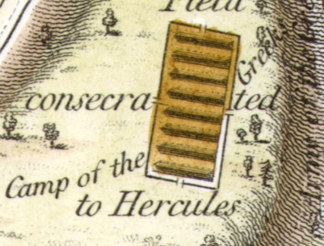
_tn.jpg) "Plan of Athens" (ancient Athens) by J.D.Barbie du Bocage, engraved
by J.Russell and published in The Travels of Anacharsis, (mid 4th century BC), 1825 (the map is dated 1817.) The original is a copper engraved plan
with recent hand colouring. Click
here for detail showing part
of the map at full resolution (500 dpi). Click the small image
to the left for a larger low resolution version. (Ref sm0124). Digital
image size 22 mb at 400 dpi. "Plan of Athens" (ancient Athens) by J.D.Barbie du Bocage, engraved
by J.Russell and published in The Travels of Anacharsis, (mid 4th century BC), 1825 (the map is dated 1817.) The original is a copper engraved plan
with recent hand colouring. Click
here for detail showing part
of the map at full resolution (500 dpi). Click the small image
to the left for a larger low resolution version. (Ref sm0124). Digital
image size 22 mb at 400 dpi.
Price 5
USD, Click here to buy
_tn.jpg) "Plan of the Environs of Athens" (ancient Athens) by J.D.Barbie du Bocage, engraved
by J.Russell and published in The Travels of Anacharsis, (mid 4th century BC), 1825 (the map is dated 1785.) The original is a copper engraved plan
with recent hand colouring. Click
here for detail showing part
of the map at full resolution (400 dpi). Click the small image
to the left for a larger low resolution version. (Ref sm0059). Digital
image size 15 mb at 400 dpi. "Plan of the Environs of Athens" (ancient Athens) by J.D.Barbie du Bocage, engraved
by J.Russell and published in The Travels of Anacharsis, (mid 4th century BC), 1825 (the map is dated 1785.) The original is a copper engraved plan
with recent hand colouring. Click
here for detail showing part
of the map at full resolution (400 dpi). Click the small image
to the left for a larger low resolution version. (Ref sm0059). Digital
image size 15 mb at 400 dpi.
Price 5
USD, Click here to buy
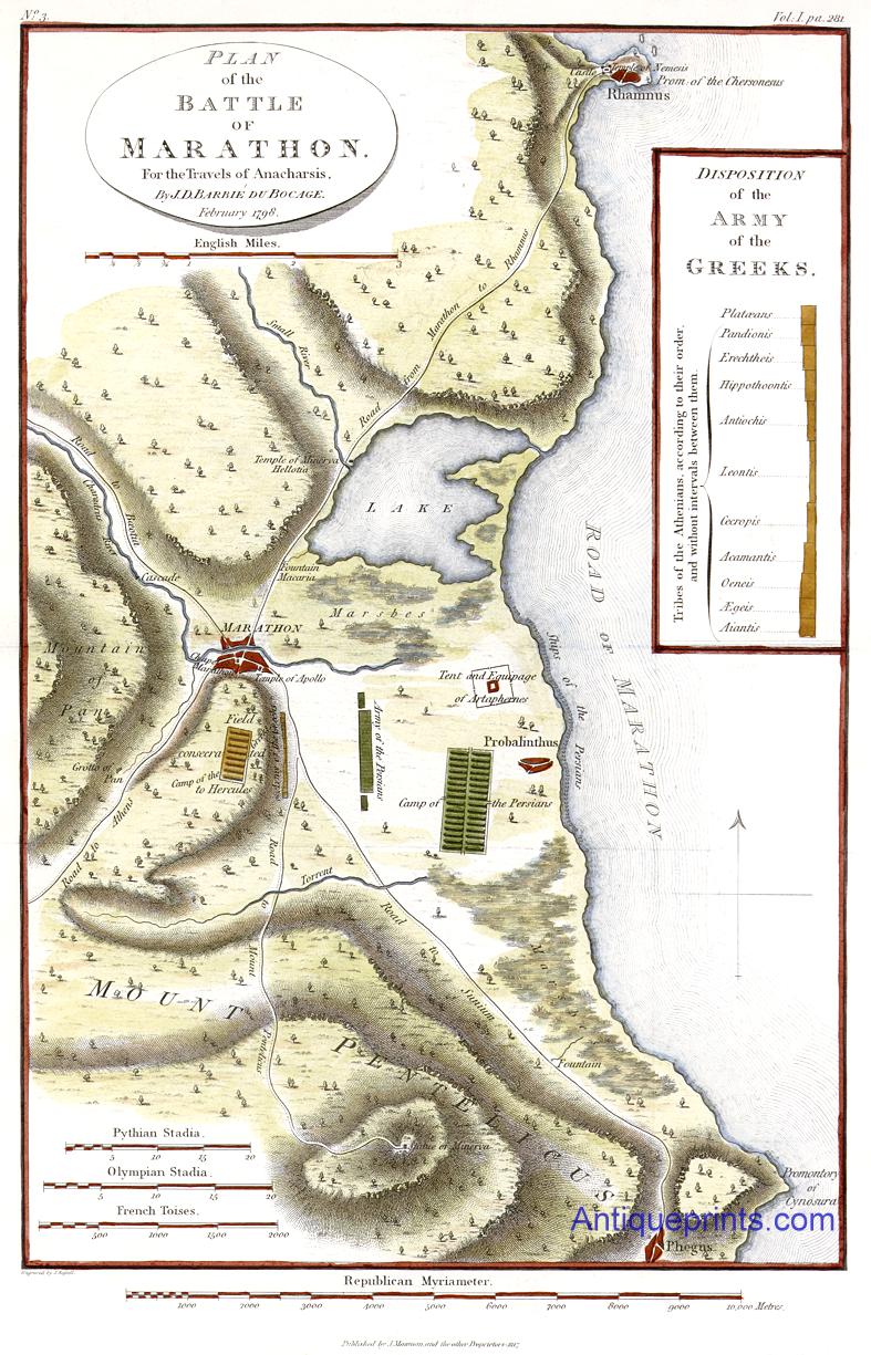
 Ancient
Greece "Plan of the Battle of Marathon ..." by J.D.Barbie
du Bocage, published in The
Travels of Anacharsis, (mid 4th century BC), London, 1825
(the map is dated 1798.) The original is a copper engraved map with
recent hand colouring. Click
here for detail showing part
of the map at full resolution (600 dpi). Click the small image
to the left for a larger low resolution version. (Ref sm0010). Digital
image size 22.3 mb at 600 dpi. Ancient
Greece "Plan of the Battle of Marathon ..." by J.D.Barbie
du Bocage, published in The
Travels of Anacharsis, (mid 4th century BC), London, 1825
(the map is dated 1798.) The original is a copper engraved map with
recent hand colouring. Click
here for detail showing part
of the map at full resolution (600 dpi). Click the small image
to the left for a larger low resolution version. (Ref sm0010). Digital
image size 22.3 mb at 600 dpi.
Price 5
USD, Click here to buy
_tn.jpg) Ancient
Greece "... The Topography of Sparta and it's Environs ..." by J.D.Barbie
du Bocage, published in The
Travels of Anacharsis ..., (mid 4th century BC), London, 1793
(the map is dated 1783.) The original is a copper engraved map measuring 20 x 31.5 cms plus margins. Click
here for detail showing part
of the map at full resolution (400 dpi). Click the small image
to the left for a larger low resolution version. (Ref sm0108). Digital
image size 13 mb at 400 dpi. Ancient
Greece "... The Topography of Sparta and it's Environs ..." by J.D.Barbie
du Bocage, published in The
Travels of Anacharsis ..., (mid 4th century BC), London, 1793
(the map is dated 1783.) The original is a copper engraved map measuring 20 x 31.5 cms plus margins. Click
here for detail showing part
of the map at full resolution (400 dpi). Click the small image
to the left for a larger low resolution version. (Ref sm0108). Digital
image size 13 mb at 400 dpi.
Price 5
USD, Click here to buy
|
|

.jpg)
.jpg)
.jpg)
-l.jpg)
.jpg)
.jpg)
-d.jpg)
-d.jpg)
-d.jpg)
-d.jpg)
-d.jpg)
-d.jpg)