|
Home
Catalogue
Information
Copyright
Other Stock Image websites

Latest additions -
Athens, ancient ruins, c1775
Pulo Penang, Malaysia, c1840
The Capitol, Washington, 1840
Middlesex county map, 1786
Philadelphia plan (SDUK), 1844
Lancashire county map, 1807
Ireland map, 1773
Austria-Hungary map, 1887
Notre Dame, Paris, 1840
Essex map, 1809
Eastern USA map, 1852
Calcutta view, 1850
Bohemia map, 1773
Dardanelles view, Turkey, 1828
Baltic Sea Tallis map, 1860
Plan of medieval Paris, 1884
Istanbul view, 1770
|
Download Royalty-free printable Stock Images of antique town and city plans of the British Isles
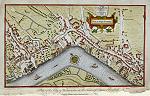
_tn.jpg) "Plan des Villes de Londres et de Westminster ..." (Plan
of London and Westminster) by Nicolas de Fer, engraved by C.Inselin, published
in Paris, about 1704 (dated 1700.) The original is a copper engraved plan
measuring 33.5 x 22.5 cms, it is trimmed to the image edge and laid down on
a larger sheet. Click
here for detail showing part
of the map at full resolution (500 dpi). Click the small image
to the left for a larger low resolution version. (Ref sm0019). Digital
image size 25 mb at 500 dpi. "Plan des Villes de Londres et de Westminster ..." (Plan
of London and Westminster) by Nicolas de Fer, engraved by C.Inselin, published
in Paris, about 1704 (dated 1700.) The original is a copper engraved plan
measuring 33.5 x 22.5 cms, it is trimmed to the image edge and laid down on
a larger sheet. Click
here for detail showing part
of the map at full resolution (500 dpi). Click the small image
to the left for a larger low resolution version. (Ref sm0019). Digital
image size 25 mb at 500 dpi.
Price 5
USD, Click here to buy
_tn.jpg) "London" (Plan) anonymous engraver, published
in Encyclopaedia Londinensis, in 1815. The original is a copper engraved plan
measuring 38 x 24.5 cms, with a small amount of original hand colouring to the city centre. Click
here for detail showing part
of the map at full resolution (400 dpi). Click the small image
to the left for a larger low resolution version. (Ref sm0139). Digital
image size 21.3 mb at 400 dpi. "London" (Plan) anonymous engraver, published
in Encyclopaedia Londinensis, in 1815. The original is a copper engraved plan
measuring 38 x 24.5 cms, with a small amount of original hand colouring to the city centre. Click
here for detail showing part
of the map at full resolution (400 dpi). Click the small image
to the left for a larger low resolution version. (Ref sm0139). Digital
image size 21.3 mb at 400 dpi.
Price 5
USD, Click here to buy
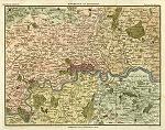
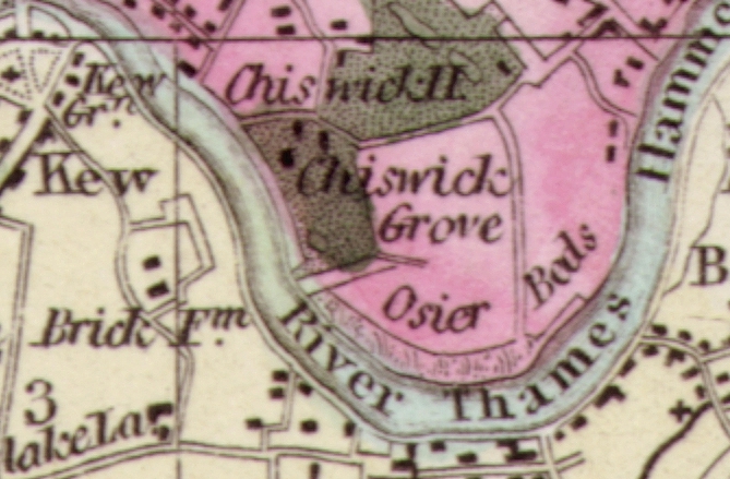
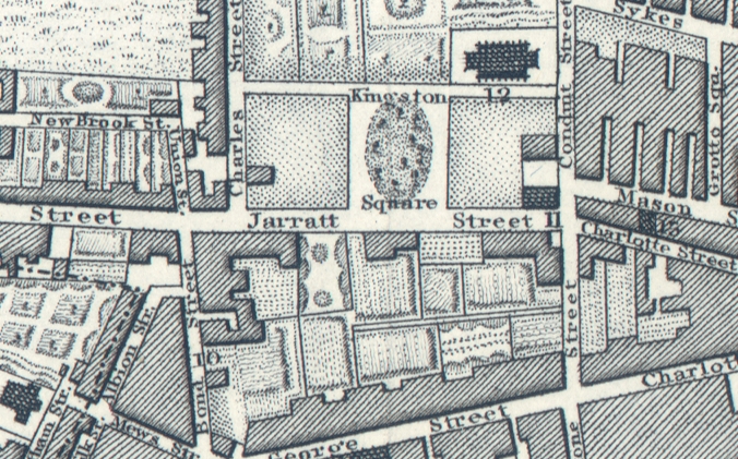
_tn.jpg) "Gegend von London, 1857" (Plan of London, 1857) published
in a German atlas, 1857. The original is an extremely detailed map of the London area, as with other maps of this date most of the rural environs shown are now within the city. Click
here for detail showing part
of the map at full resolution (500 dpi). Click the small image
to the left for a larger low resolution version. (Ref sm0077). Digital
image size 20 mb at 500 dpi. "Gegend von London, 1857" (Plan of London, 1857) published
in a German atlas, 1857. The original is an extremely detailed map of the London area, as with other maps of this date most of the rural environs shown are now within the city. Click
here for detail showing part
of the map at full resolution (500 dpi). Click the small image
to the left for a larger low resolution version. (Ref sm0077). Digital
image size 20 mb at 500 dpi.
Price 5
USD, Click here to buy
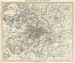
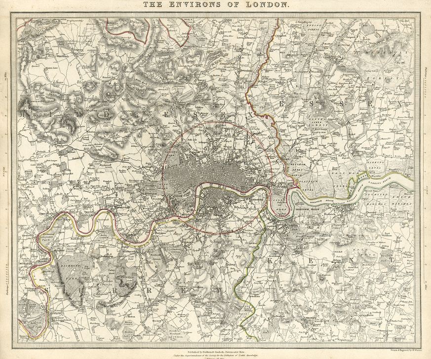
_tn.jpg) "Plan of London, Metropolitan Burghs and Southern and Eastern Environs " drawn and engraved by J.Bartholomew, published
in The Imperial Gazetteer, 1866. The original is a lithographic plan with original hand colour. A detailed map illustrating mid-Victorian London, most of the rural environs shown are now within the city. Click
here for detail showing part
of the map at full resolution (500 dpi). Click the small image
to the left for a larger low resolution version. (Ref sm0034). Digital
image size 21 mb at 500 dpi. "Plan of London, Metropolitan Burghs and Southern and Eastern Environs " drawn and engraved by J.Bartholomew, published
in The Imperial Gazetteer, 1866. The original is a lithographic plan with original hand colour. A detailed map illustrating mid-Victorian London, most of the rural environs shown are now within the city. Click
here for detail showing part
of the map at full resolution (500 dpi). Click the small image
to the left for a larger low resolution version. (Ref sm0034). Digital
image size 21 mb at 500 dpi.
Price 5
USD, Click here to buy
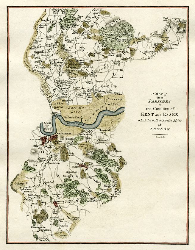
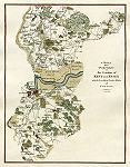 "A Map of those Parishes in the Counties of Kent and Essex which lie within Twelve Miles of London" by J Cary, published in Lyson's The Environs of London, 1796. The original is a copper engraved map with later hand colour. Size of the original is 18 x 23 cms. Click
here for detail showing part
of the map at full resolution (500 dpi). Click the small image
to the left for a larger low resolution version. (Ref sm0213). Digital
image size 10.7 mb at 500 dpi. "A Map of those Parishes in the Counties of Kent and Essex which lie within Twelve Miles of London" by J Cary, published in Lyson's The Environs of London, 1796. The original is a copper engraved map with later hand colour. Size of the original is 18 x 23 cms. Click
here for detail showing part
of the map at full resolution (500 dpi). Click the small image
to the left for a larger low resolution version. (Ref sm0213). Digital
image size 10.7 mb at 500 dpi.
Price 5
USD, Click here to buy
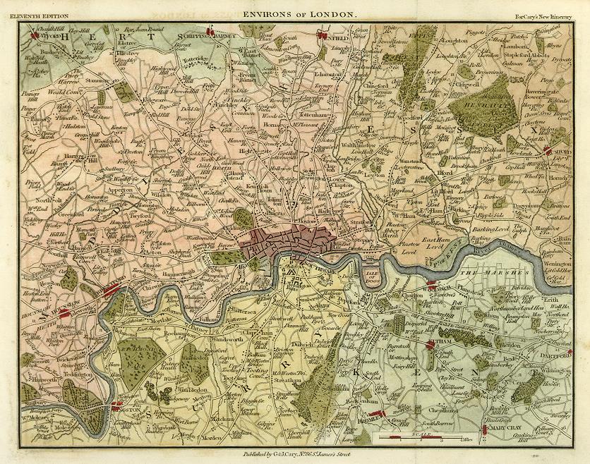
 "Environs of London" published
in C & J Cary's New Itinerary, (11th edition) about 1815. The original is a copper engraved map with later hand colour. An intersting map with much detail of the rural areas now incorporated into London. NOTE - the original has two folds which show in the scan. Click
here for detail showing part
of the map at full resolution (600 dpi). Click the small image
to the left for a larger low resolution version. (Ref sm0070). Digital
image size 16.5 mb at 600 dpi. "Environs of London" published
in C & J Cary's New Itinerary, (11th edition) about 1815. The original is a copper engraved map with later hand colour. An intersting map with much detail of the rural areas now incorporated into London. NOTE - the original has two folds which show in the scan. Click
here for detail showing part
of the map at full resolution (600 dpi). Click the small image
to the left for a larger low resolution version. (Ref sm0070). Digital
image size 16.5 mb at 600 dpi.
Price 5
USD, Click here to buy
 "Environs of London" published
in Thomas Moule's English Counties ..., 1837. The original is a steel engraved map with full original hand colour. A small but decorative map illustrating early-Victorian London and vicinity, most of the environs shown are now within the city. Click
here for detail showing part
of the map at full resolution (600 dpi). Click the small image
to the left for a larger low resolution version. (Ref sm0067). Digital
image size 36 mb at 600 dpi. "Environs of London" published
in Thomas Moule's English Counties ..., 1837. The original is a steel engraved map with full original hand colour. A small but decorative map illustrating early-Victorian London and vicinity, most of the environs shown are now within the city. Click
here for detail showing part
of the map at full resolution (600 dpi). Click the small image
to the left for a larger low resolution version. (Ref sm0067). Digital
image size 36 mb at 600 dpi.
Price 5
USD, Click here to buy
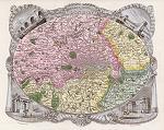
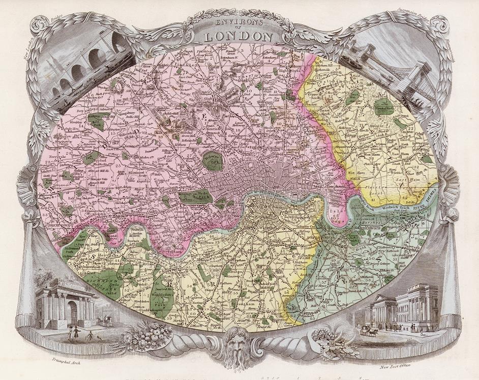
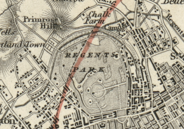
 "The Environs of London" drawn and engraved by H.Waters, published by the 'Society for the Diffusion of Useful Knowledge',
in 1832. The original is a very detailed steel engraved antique plan with original hand colour
measuring 38.5 x 32 cms. In 1832 areas such as Hackney, Islington, Chelsea and Camberwell were in the countryside. Click
here for detail showing part
of the map at full resolution (500 dpi). Click the small image
to the left for a larger low resolution version. (Ref sm0239). Digital
image size 39.3 mb at 500 dpi. "The Environs of London" drawn and engraved by H.Waters, published by the 'Society for the Diffusion of Useful Knowledge',
in 1832. The original is a very detailed steel engraved antique plan with original hand colour
measuring 38.5 x 32 cms. In 1832 areas such as Hackney, Islington, Chelsea and Camberwell were in the countryside. Click
here for detail showing part
of the map at full resolution (500 dpi). Click the small image
to the left for a larger low resolution version. (Ref sm0239). Digital
image size 39.3 mb at 500 dpi.
Price 5
USD, Click here to buy
_tn.jpg) "Plan of London in the Reign of Queen Elizabeth" (about 1580) anonymous engraver, published in Hughson's London ... History and Description ..., about 1808. The original is a long copper engraved plan
with later hand colouring. Click
here for detail showing part
of the map at full resolution (600 dpi). Click the small image
to the left for a larger low resolution version. (Ref sm0127). Digital
image size 41 mb at 600 dpi. "Plan of London in the Reign of Queen Elizabeth" (about 1580) anonymous engraver, published in Hughson's London ... History and Description ..., about 1808. The original is a long copper engraved plan
with later hand colouring. Click
here for detail showing part
of the map at full resolution (600 dpi). Click the small image
to the left for a larger low resolution version. (Ref sm0127). Digital
image size 41 mb at 600 dpi.
Price 5
USD, Click here to buy
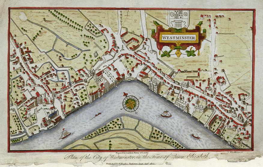
 "Plan of the City of Westminster in the time of Queen Elizabeth" (about 1580) engraved
by Woodthorpe after an original plan, published in Lambert's History of London, 1805. The original is a small copper engraved plan
with later hand colouring, NOTE - the lower margin and title area is damaged, but the plan itself is fine. Click
here for detail showing part
of the map at full resolution (500 dpi). Click the small image
to the left for a larger low resolution version. (Ref sm0069). Digital
image size 8 mb at 500 dpi. "Plan of the City of Westminster in the time of Queen Elizabeth" (about 1580) engraved
by Woodthorpe after an original plan, published in Lambert's History of London, 1805. The original is a small copper engraved plan
with later hand colouring, NOTE - the lower margin and title area is damaged, but the plan itself is fine. Click
here for detail showing part
of the map at full resolution (500 dpi). Click the small image
to the left for a larger low resolution version. (Ref sm0069). Digital
image size 8 mb at 500 dpi.
Price 5
USD, Click here to buy
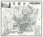
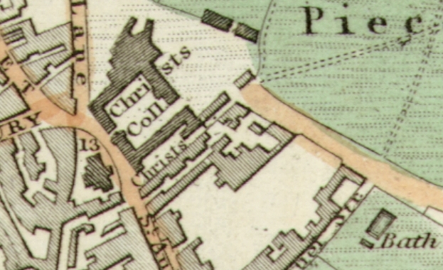
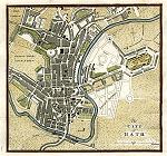 "The City of Bath" published
in Guide to all the Watering and Sea Bathing Places ..., 1810. The original is a copper engraved plan measuring 17.5 x 16.5 cms plus margins. Later hand colouring. Click
here for detail showing part
of the plan at full resolution (300 dpi). Click the small image
to the left for a larger low resolution version. (Ref sm0192). Digital
image size 4.3 mb at 300 dpi. "The City of Bath" published
in Guide to all the Watering and Sea Bathing Places ..., 1810. The original is a copper engraved plan measuring 17.5 x 16.5 cms plus margins. Later hand colouring. Click
here for detail showing part
of the plan at full resolution (300 dpi). Click the small image
to the left for a larger low resolution version. (Ref sm0192). Digital
image size 4.3 mb at 300 dpi.
Price 5
USD, Click here to buy
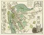
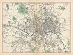
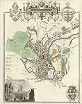 "City of Bath" published
in Thomas Moule's English Counties ..., 1837. The original is a detailed steel engraved plan with full original hand colour. A very decorative plan of the city, incorporating a view of the Guildhall & Abbey as well as several coats of arms. Click
here for detail showing part
of the plan at full resolution (600 dpi). Click the small image
to the left for a larger low resolution version. (Ref sm0097). Digital
image size 25 mb at 600 dpi. "City of Bath" published
in Thomas Moule's English Counties ..., 1837. The original is a detailed steel engraved plan with full original hand colour. A very decorative plan of the city, incorporating a view of the Guildhall & Abbey as well as several coats of arms. Click
here for detail showing part
of the plan at full resolution (600 dpi). Click the small image
to the left for a larger low resolution version. (Ref sm0097). Digital
image size 25 mb at 600 dpi.
Price 5
USD, Click here to buy
_tn.jpg) "Birmingham" engraved by J.Bartholomew and originally published by A. Fullarton & Co. in The Imperial Gazetteer of England & Wales, 1866. The scanned original is a lithographic plan
measuring 31.5 x 24.5 cms, the hand colouring is original. There is a centrefold and some slight foxing which are visible on the image. Click
here for detail showing part
of the map (Five Ways area) at full resolution (500 dpi). Click the small image
to the left for a larger low resolution version. (Ref sm0119). Digital
image size 23.5 mb at 500 dpi. "Birmingham" engraved by J.Bartholomew and originally published by A. Fullarton & Co. in The Imperial Gazetteer of England & Wales, 1866. The scanned original is a lithographic plan
measuring 31.5 x 24.5 cms, the hand colouring is original. There is a centrefold and some slight foxing which are visible on the image. Click
here for detail showing part
of the map (Five Ways area) at full resolution (500 dpi). Click the small image
to the left for a larger low resolution version. (Ref sm0119). Digital
image size 23.5 mb at 500 dpi.
Price 5
USD, Click here to buy
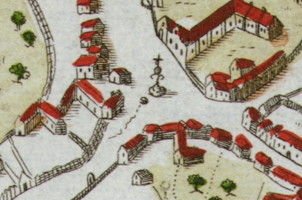
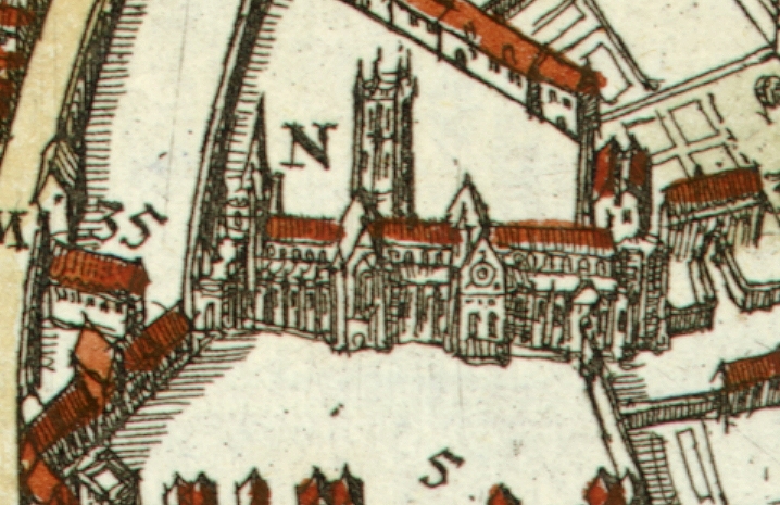
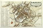 "A Ground Plott of Canterbury" by Wenceslas Hollar, origianlly published about 1670, this historical plan of Canterbury is taken from a strike off the original plate, printed about 1795. The scanned original is a copper engraved plan
with recent hand colouring. To the upper left, especially in the key area, can be seen some evidence of damage to the plate, or possibly some show-through of an etching on the reverse side of the copper plate. Click
here for detail showing part
of the map at full resolution (600 dpi). Click the small image
to the left for a larger low resolution version. (Ref sm0063). Digital
image size 23 mb at 600 dpi. "A Ground Plott of Canterbury" by Wenceslas Hollar, origianlly published about 1670, this historical plan of Canterbury is taken from a strike off the original plate, printed about 1795. The scanned original is a copper engraved plan
with recent hand colouring. To the upper left, especially in the key area, can be seen some evidence of damage to the plate, or possibly some show-through of an etching on the reverse side of the copper plate. Click
here for detail showing part
of the map at full resolution (600 dpi). Click the small image
to the left for a larger low resolution version. (Ref sm0063). Digital
image size 23 mb at 600 dpi.
Price 5
USD, Click here to buy
_tn.jpg) "Plan of the University and Town of Cambridge" engraved
by Neele, published in Magna Britannia .., 1808. The original is a copper engraved plan
measuring 19 x 24 cms. Click
here for detail showing part
of the map at full resolution (500 dpi). Click the small image
to the left for a larger low resolution version. (Ref sm0020). Digital
image size 13.5 mb at 500 dpi. "Plan of the University and Town of Cambridge" engraved
by Neele, published in Magna Britannia .., 1808. The original is a copper engraved plan
measuring 19 x 24 cms. Click
here for detail showing part
of the map at full resolution (500 dpi). Click the small image
to the left for a larger low resolution version. (Ref sm0020). Digital
image size 13.5 mb at 500 dpi.
Price 5
USD, Click here to buy
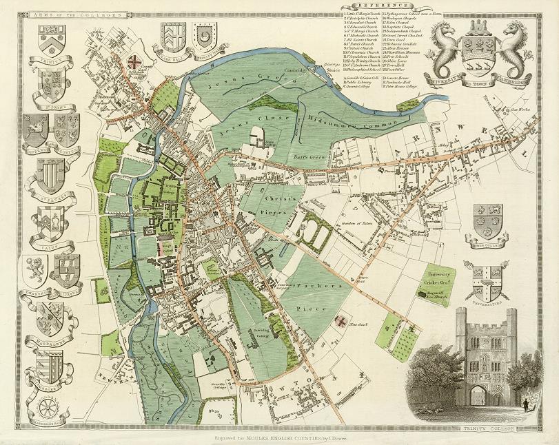
 "University and Town of Cambridge" engraved by J.Dower and published
in Thomas Moule's English Counties ..., 1837. The original is a detailed steel engraved map with full original hand colour. A very decorative plan of the city, incorporating a view of Trinity College and numerous coats of arms of the colleges. Click
here for detail showing part
of the map at full resolution (600 dpi). Click the small image
to the left for a larger low resolution version. (Ref sm0100). Digital
image size 20 mb at 600 dpi. "University and Town of Cambridge" engraved by J.Dower and published
in Thomas Moule's English Counties ..., 1837. The original is a detailed steel engraved map with full original hand colour. A very decorative plan of the city, incorporating a view of Trinity College and numerous coats of arms of the colleges. Click
here for detail showing part
of the map at full resolution (600 dpi). Click the small image
to the left for a larger low resolution version. (Ref sm0100). Digital
image size 20 mb at 600 dpi.
Price 5
USD, Click here to buy
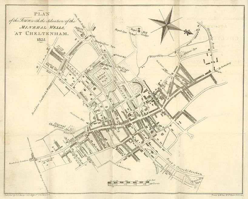
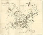 "Plan of the Town with the situation of the Mineral Wells, at Cheltenham. 1825" by Fosbroke, printed by W.Day & Son and published
by S.C.Harper (350, High St., Cheltenham) in Rev. T. Fosbroke's Picturesque and Topographical Acount of Cheltenham ..., 1825. The original is a copper engraved plan which has several folds that are evident in this image. An interesting plan showng the town just after the new Promenade was laid out, which terminated at Sherborne Spa, where the Queens Hotel now stands. Click
here for detail showing what is now Imperial Gardens (then Botanical Gardens) at full resolution (400 dpi). Click the small image
to the left for a larger low resolution version. (Ref sm0103). Digital
image size 10 mb at 400 dpi. "Plan of the Town with the situation of the Mineral Wells, at Cheltenham. 1825" by Fosbroke, printed by W.Day & Son and published
by S.C.Harper (350, High St., Cheltenham) in Rev. T. Fosbroke's Picturesque and Topographical Acount of Cheltenham ..., 1825. The original is a copper engraved plan which has several folds that are evident in this image. An interesting plan showng the town just after the new Promenade was laid out, which terminated at Sherborne Spa, where the Queens Hotel now stands. Click
here for detail showing what is now Imperial Gardens (then Botanical Gardens) at full resolution (400 dpi). Click the small image
to the left for a larger low resolution version. (Ref sm0103). Digital
image size 10 mb at 400 dpi.
Price 5
USD, Click here to buy
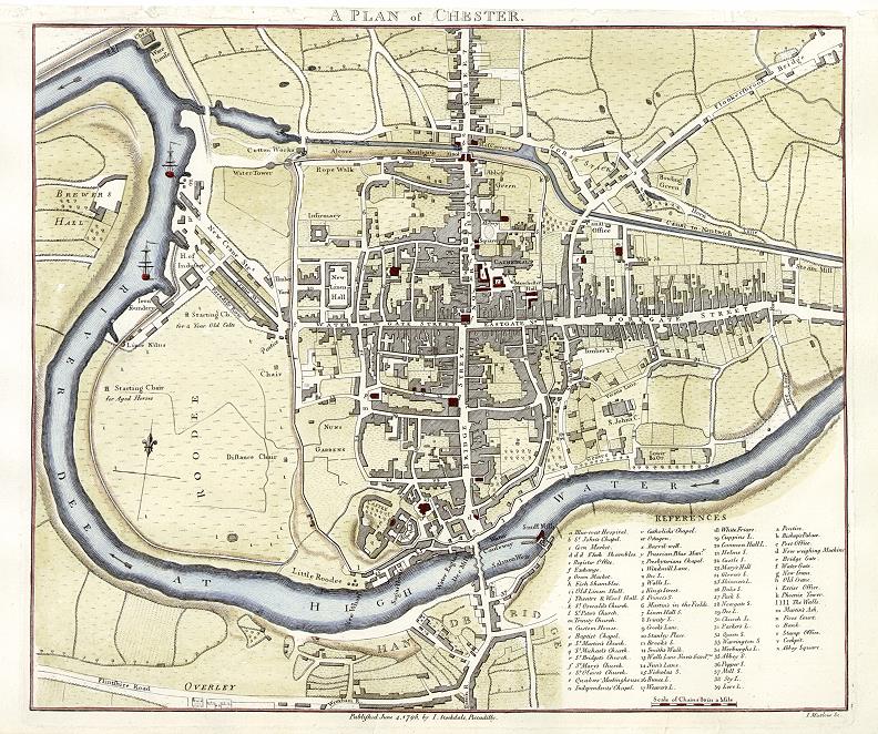
 "A Plan of Chester" engraved
by J.Mutlow, published by John Stockdale in 1795. The original is a copper engraved plan
with recent hand colouring. Click
here for detail showing part
of the map at full resolution (600 dpi). Click the small image
to the left for a larger low resolution version. (Ref sm0058). Digital
image size 27 mb at 600 dpi. "A Plan of Chester" engraved
by J.Mutlow, published by John Stockdale in 1795. The original is a copper engraved plan
with recent hand colouring. Click
here for detail showing part
of the map at full resolution (600 dpi). Click the small image
to the left for a larger low resolution version. (Ref sm0058). Digital
image size 27 mb at 600 dpi.
Price 5
USD, Click here to buy
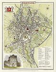
_tn.jpg) "Durham" engraved
by J.Roper after a plan by G.Cole, published in The Beauties of England & Wales, 1806. With a numbered key to places of interest. The original is a copper engraved plan
with recent hand colouring. Click
here for detail showing part
of the map at full resolution (500 dpi). Click the small image
to the left for a larger low resolution version. (Ref sm0128). Digital
image size 12.5 mb at 500 dpi. "Durham" engraved
by J.Roper after a plan by G.Cole, published in The Beauties of England & Wales, 1806. With a numbered key to places of interest. The original is a copper engraved plan
with recent hand colouring. Click
here for detail showing part
of the map at full resolution (500 dpi). Click the small image
to the left for a larger low resolution version. (Ref sm0128). Digital
image size 12.5 mb at 500 dpi.
Price 5
USD, Click here to buy
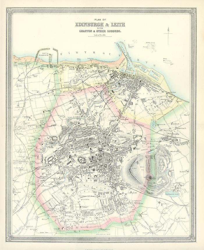
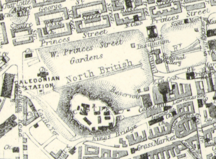
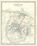 "Plan of Edinburgh & Leith with Granton & other Suburbs" published by A. Fullarton & Co. in The Imperial Gazetteer of England & Wales, 1865. The scanned original is a lithographic plan
with lithographic colour. Click
here for detail showing part
of the map at full resolution (500 dpi). Click the small image
to the left for a larger low resolution version. (Ref sm0190). Digital
image size 17.4 mb at 500 dpi. "Plan of Edinburgh & Leith with Granton & other Suburbs" published by A. Fullarton & Co. in The Imperial Gazetteer of England & Wales, 1865. The scanned original is a lithographic plan
with lithographic colour. Click
here for detail showing part
of the map at full resolution (500 dpi). Click the small image
to the left for a larger low resolution version. (Ref sm0190). Digital
image size 17.4 mb at 500 dpi.
Price 5
USD, Click here to buy
_tn.jpg) "City of Glasgow" drawn and engraved by G.H.Swanston, published
in Fullarton's Gazetter of Scotland, about
1865. The original is a lithographic plan
with original hand colouring, it has one vertical fold, visible
in the image. Click
here for detail showing part
of the map at full resolution (500 dpi). Click the small image
to the left for a larger low resolution version. (Ref sm0066). Digital
image size 19.5 mb at 500 dpi. "City of Glasgow" drawn and engraved by G.H.Swanston, published
in Fullarton's Gazetter of Scotland, about
1865. The original is a lithographic plan
with original hand colouring, it has one vertical fold, visible
in the image. Click
here for detail showing part
of the map at full resolution (500 dpi). Click the small image
to the left for a larger low resolution version. (Ref sm0066). Digital
image size 19.5 mb at 500 dpi.
Price 5
USD, Click here to buy
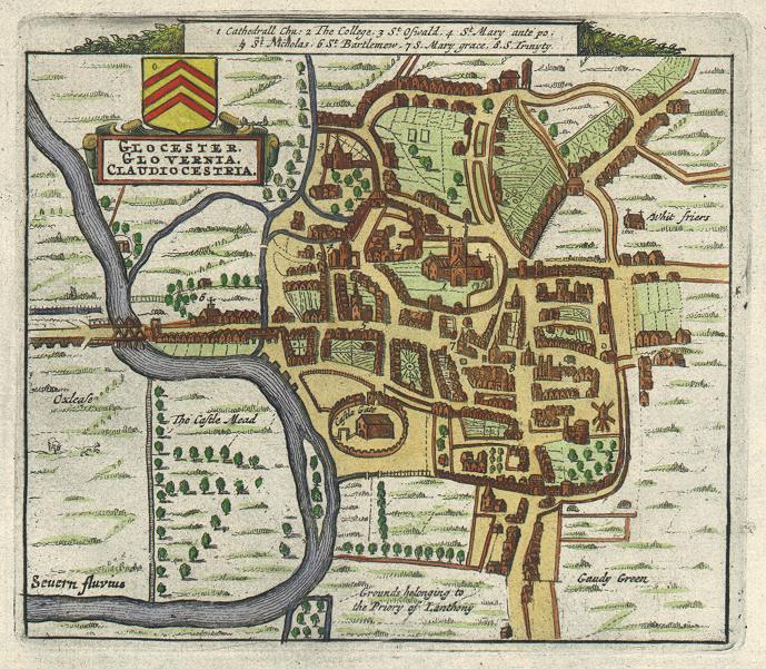
 "Glocester. Glovernia. Claudiocestria" town plan by Pierre Van Der Aa of about 1720, based on the original by John Speed of 1610. The original is a copper engraved antique plan, with recent hand colouring, measuring 13 x 12 cms plus margins. Click
here for detail showing part
of the map at full resolution (500 dpi). Click the small image
to the left for a larger low resolution version. (Ref sm0238). Digital
image size 5.8 mb at 500 dpi. "Glocester. Glovernia. Claudiocestria" town plan by Pierre Van Der Aa of about 1720, based on the original by John Speed of 1610. The original is a copper engraved antique plan, with recent hand colouring, measuring 13 x 12 cms plus margins. Click
here for detail showing part
of the map at full resolution (500 dpi). Click the small image
to the left for a larger low resolution version. (Ref sm0238). Digital
image size 5.8 mb at 500 dpi.
Price 5
USD, Click here to buy
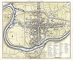
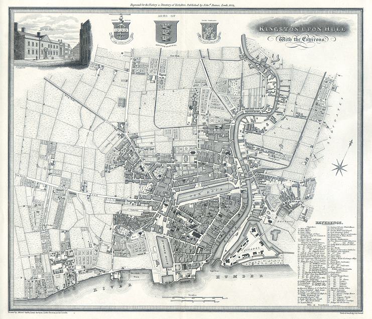
 "Kingston Upon Hull with the Environs" engraved plan by Neele & Son after a plan by Alfred Smith (surveyor), published in The History & Directory of Yorkshire, 1822. The original is a detailed copper engraved plan, it has one vertical fold, just visible
in the image. Click
here for detail showing part
of the map at full resolution (400 dpi). Click the small image
to the left for a larger low resolution version. (Ref sm0225). Digital
image size 22 mb at 400 dpi. "Kingston Upon Hull with the Environs" engraved plan by Neele & Son after a plan by Alfred Smith (surveyor), published in The History & Directory of Yorkshire, 1822. The original is a detailed copper engraved plan, it has one vertical fold, just visible
in the image. Click
here for detail showing part
of the map at full resolution (400 dpi). Click the small image
to the left for a larger low resolution version. (Ref sm0225). Digital
image size 22 mb at 400 dpi.
Price 5
USD, Click here to buy
_tn.jpg) "Plan of the Town of Leeds, with the recent Improvements. Surveyed in 1821 by Chas. Fowler, Leeds" engraved plan by Neele & Son after a survey by Charles Fowler, published in The History & Directory of Yorkshire, 1822. The original is a detailed copper engraved plan, it has one horizontal fold, visible
in the image. Click
here for detail showing part
of the map at full resolution (400 dpi). Click the small image
to the left for a larger low resolution version. (Ref sm0207). Digital
image size 17.5 mb at 400 dpi. "Plan of the Town of Leeds, with the recent Improvements. Surveyed in 1821 by Chas. Fowler, Leeds" engraved plan by Neele & Son after a survey by Charles Fowler, published in The History & Directory of Yorkshire, 1822. The original is a detailed copper engraved plan, it has one horizontal fold, visible
in the image. Click
here for detail showing part
of the map at full resolution (400 dpi). Click the small image
to the left for a larger low resolution version. (Ref sm0207). Digital
image size 17.5 mb at 400 dpi.
Price 5
USD, Click here to buy
 "Leeds. From Ordnance & Actual Survey" engraved by J.Bartholomew and originally published by A. Fullarton & Co. in The Imperial Gazetteer of England & Wales, about 1855. The original is a lithographic plan
with original hand colouring. There is a centrefold which is visible on the image. Click
here for detail showing part
of the map at full resolution (200 dpi). Click the small image
to the left for a larger low resolution version. (Ref sm0208). Digital
image size 1.6 mb at 200 dpi. "Leeds. From Ordnance & Actual Survey" engraved by J.Bartholomew and originally published by A. Fullarton & Co. in The Imperial Gazetteer of England & Wales, about 1855. The original is a lithographic plan
with original hand colouring. There is a centrefold which is visible on the image. Click
here for detail showing part
of the map at full resolution (200 dpi). Click the small image
to the left for a larger low resolution version. (Ref sm0208). Digital
image size 1.6 mb at 200 dpi.
Price 5
USD, Click here to buy
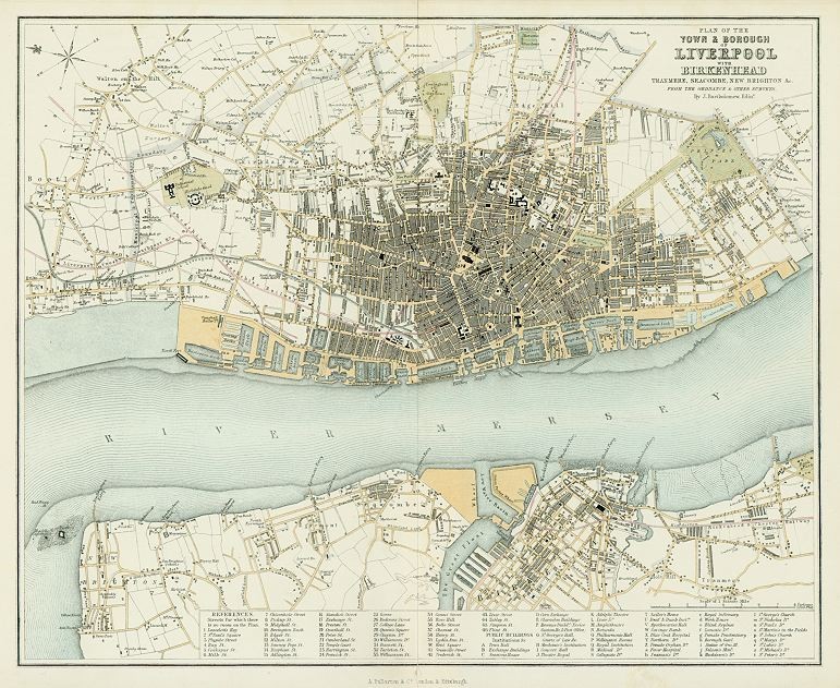
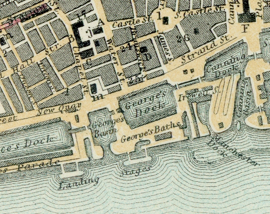
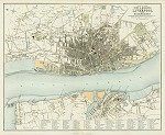 "Plan of the Town & Borough of Liverpool with Birkenhead, Tranmere, Seacombe, New Brighton &c." by J.Bartholomew and originally published by A. Fullarton & Co. in The Imperial Gazetteer of England & Wales, 1865. The original is a lithographic plan
with original hand colouring. There is a centrefold which is visible on the image. Click
here for detail showing part
of the map at full resolution (400 dpi). Click the small image
to the left for a larger low resolution version. (Ref sm0228). Digital
image size 18.3 mb at 400 dpi. "Plan of the Town & Borough of Liverpool with Birkenhead, Tranmere, Seacombe, New Brighton &c." by J.Bartholomew and originally published by A. Fullarton & Co. in The Imperial Gazetteer of England & Wales, 1865. The original is a lithographic plan
with original hand colouring. There is a centrefold which is visible on the image. Click
here for detail showing part
of the map at full resolution (400 dpi). Click the small image
to the left for a larger low resolution version. (Ref sm0228). Digital
image size 18.3 mb at 400 dpi.
Price 5
USD, Click here to buy
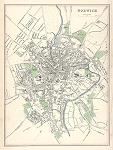
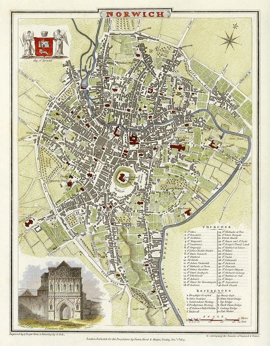
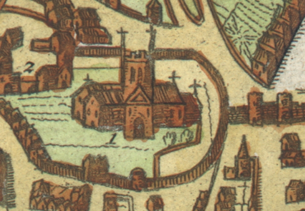
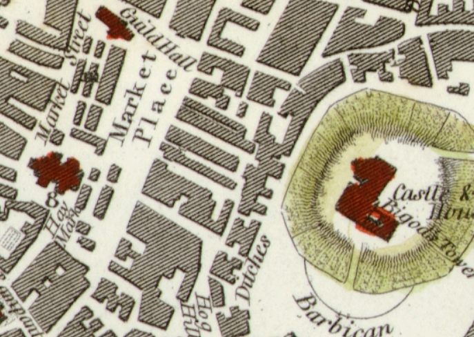
 "Norwich" engraved
by J.Roper after a plan by G.Cole, published in The Beauties of England & Wales, 1806. With a numbered key to places of interest. The original is a copper engraved plan
with recent hand colouring. Click
here for detail showing part
of the map at full resolution (500 dpi). Click the small image
to the left for a larger low resolution version. (Ref sm0186). Digital
image size 14.7 mb at 500 dpi. "Norwich" engraved
by J.Roper after a plan by G.Cole, published in The Beauties of England & Wales, 1806. With a numbered key to places of interest. The original is a copper engraved plan
with recent hand colouring. Click
here for detail showing part
of the map at full resolution (500 dpi). Click the small image
to the left for a larger low resolution version. (Ref sm0186). Digital
image size 14.7 mb at 500 dpi.
Price 5
USD, Click here to buy
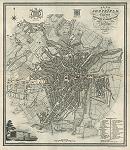
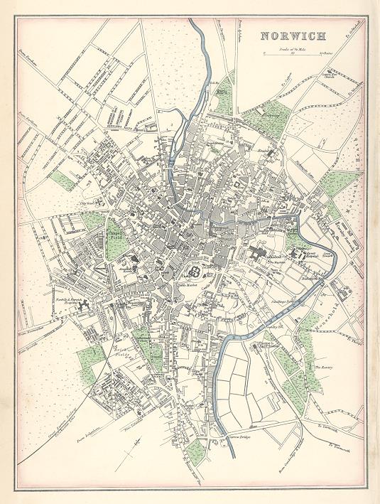
 "Norwich" published by A. Fullarton & Co. in The Imperial Gazetteer of England & Wales, 1866. The original is a lithographic plan with original hand colouring. Click
here for detail showing part
of the map at full resolution (500 dpi). Click the small image
to the left for a larger low resolution version. (Ref sm0243). Digital
image size 12.3 mb at 500 dpi. "Norwich" published by A. Fullarton & Co. in The Imperial Gazetteer of England & Wales, 1866. The original is a lithographic plan with original hand colouring. Click
here for detail showing part
of the map at full resolution (500 dpi). Click the small image
to the left for a larger low resolution version. (Ref sm0243). Digital
image size 12.3 mb at 500 dpi.
Price 5
USD, Click here to buy
_tn.jpg) "Oxford" engraved
by J.Roper after a plan by G.Cole, published in The Beauties of England & Wales, 1806. With a numbered key to all the Colleges, Universities and Halls. The original is a copper engraved plan
with recent hand colouring. Click
here for detail showing part
of the map at full resolution (500 dpi). Click the small image
to the left for a larger low resolution version. (Ref sm0048). Digital
image size 15 mb at 500 dpi. "Oxford" engraved
by J.Roper after a plan by G.Cole, published in The Beauties of England & Wales, 1806. With a numbered key to all the Colleges, Universities and Halls. The original is a copper engraved plan
with recent hand colouring. Click
here for detail showing part
of the map at full resolution (500 dpi). Click the small image
to the left for a larger low resolution version. (Ref sm0048). Digital
image size 15 mb at 500 dpi.
Price 5
USD, Click here to buy
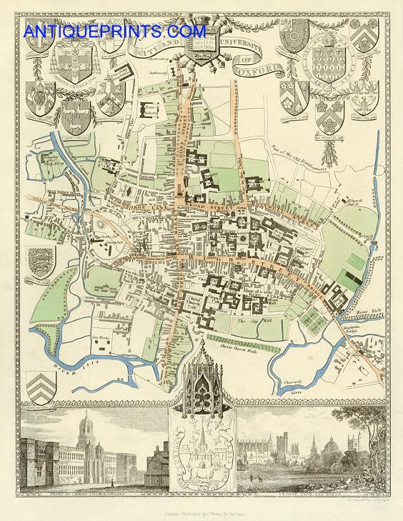
 "City and University of Oxford" engraved by J.Cleghorn, published
in Thomas Moule's English Counties ..., 1837. The original is a detailed steel engraved map with full original hand colour. A very decorative plan of the city, incorporating views of Oxford from the north and Christ Church College, as well as the coats of arms for many other colleges. Click
here for detail showing part
of the map at full resolution (600 dpi). Click the small image
to the left for a larger low resolution version. (Ref sm0079). Digital
image size 17 mb at 600 dpi. "City and University of Oxford" engraved by J.Cleghorn, published
in Thomas Moule's English Counties ..., 1837. The original is a detailed steel engraved map with full original hand colour. A very decorative plan of the city, incorporating views of Oxford from the north and Christ Church College, as well as the coats of arms for many other colleges. Click
here for detail showing part
of the map at full resolution (600 dpi). Click the small image
to the left for a larger low resolution version. (Ref sm0079). Digital
image size 17 mb at 600 dpi.
Price 5
USD, Click here to buy
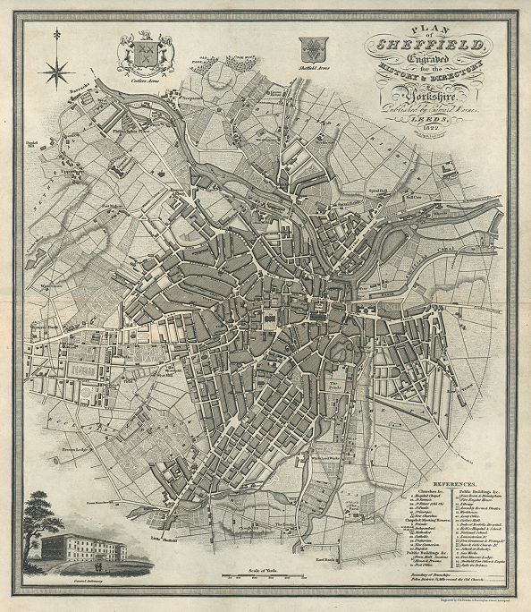
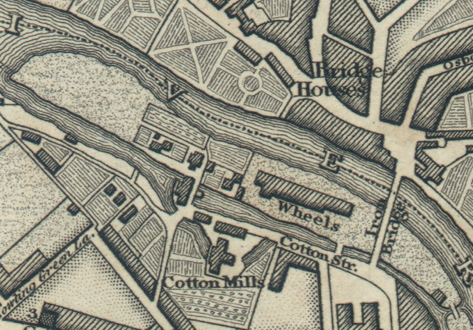
 "Plan of Sheffield ..." engraved plan by Neele & Son after a survey by Alfred Smith (1822), published in The History & Directory of Yorkshire, 1822. The original is a detailed copper engraved plan, it has one horizontal fold, visible
in the image. Click
here for detail showing part
of the map at full resolution (400 dpi). Click the small image
to the left for a larger low resolution version. (Ref sm0224). Digital
image size 21.6 mb at 400 dpi. "Plan of Sheffield ..." engraved plan by Neele & Son after a survey by Alfred Smith (1822), published in The History & Directory of Yorkshire, 1822. The original is a detailed copper engraved plan, it has one horizontal fold, visible
in the image. Click
here for detail showing part
of the map at full resolution (400 dpi). Click the small image
to the left for a larger low resolution version. (Ref sm0224). Digital
image size 21.6 mb at 400 dpi.
Price 5
USD, Click here to buy
_tn.jpg) "York" engraved plan by Neele & Son after a survey by Alfred Smith, published in The History & Directory of Yorkshire, 1822. The original is a detailed copper engraved plan, it has one horizontal fold, visible
in the image. Click
here for detail showing part
of the map at full resolution (400 dpi). Click the small image
to the left for a larger low resolution version. (Ref sm0118). Digital
image size 21.2 mb at 400 dpi. "York" engraved plan by Neele & Son after a survey by Alfred Smith, published in The History & Directory of Yorkshire, 1822. The original is a detailed copper engraved plan, it has one horizontal fold, visible
in the image. Click
here for detail showing part
of the map at full resolution (400 dpi). Click the small image
to the left for a larger low resolution version. (Ref sm0118). Digital
image size 21.2 mb at 400 dpi.
Price 5
USD, Click here to buy
|
|

-s.jpg)
-l.jpg)
-s.jpg)
.jpg)
-l.jpg)


-l.jpg)

-s.jpg)
-l.jpg)
-s.jpg)
-l.jpg)

.jpg)
-l.jpg)
-d.jpg)
-d.jpg)
-d.jpg)
-d.jpg)
-d.jpg)
-d.jpg)
-d.jpg)
-d.jpg)
-d.jpg)
-d.jpg)
-d.jpg)
-d.jpg)
-d.jpg)